Document Actions
Noise mapping and sound environments: study the city with mobile tools
Back to Project Geomatics and EDD
Study Context
This experiment is part of the new geography curriculum in high school (Theme 3: "Develop the city," chapter "Cities and Sustainable Development"). According to official instructions, this topic is addressed "from two case studies put into perspective, the one chosen in developed countries, the other in emerging or developing." It is organized around three main issues: that of the growth and urban sprawl, that of transportation and mobility, and finally that of city planning "sustainable".
It relies on a field trip to a nearby urban area (ie Limoges), which can be adapted to other cities.
Implementation
For the first case of study, the choice fell on a set of French cities at different scales: Paris, Nantes and Limoges. The entry in this case study is done by studying the noise mapping and noise urban environments, pollution vectors and facilities in cities characterized by urban sprawl and the issue of communications lines. This experiment is based on different types of documents:
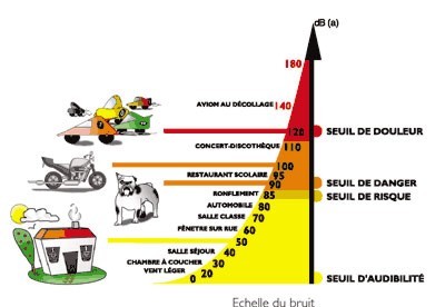
- A noise mapping available for Nantes and Paris, performed by professionals across a large metropolis and a city.
- A field trip to meet noise and sound levels in order to construct a
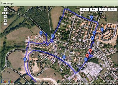
mapping of two sensitive areas of Limoges and its suburbs (Landouge and
the district of the town hall).
This study points to common ideas but also to identify significant differences, depending on the importance of the metropolis.
Course:
This activity involves and mobilizes three classes of two different levels:
- A class of 14 aged students computer with the computer option
- Two classes in high school
- The first participates to the output inLimoges, collecting data, interpreting them through a mapping
- The second works on noise mapping analysis of Paris and Nantes.
The work of both classes is pooled with a summary by the two classes.
Role oh the 14 years old students
Students in third CTBT play here the role of expert in the tools and mobile.
They create and offer solutions for mobile phone to record and measure the noise at the output.
These students have a particular profile because they have a computer and more time since the beginning of the year.
Several choices have been made according to the possibilities:
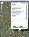
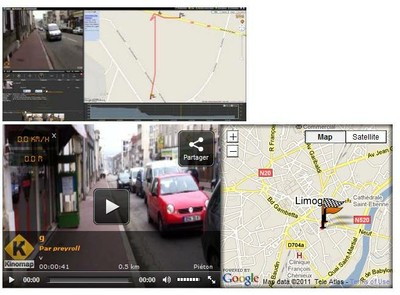
My Tracks is an application that interfaces with Google Maps and Google Navigation. It allows real-time geo bearer of the tape and display the distance traveled directly into Google Maps. This course is accompanied by statements of levels and can be exported to KMZ to rework it later.
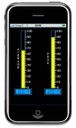
Sonomètre is an application of sound records on IOS and Android platforms.
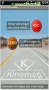
Kinomap is a particular application that lets you view the environment differently (i.e. "Les applications mobiles géolocalisées en géographie, published in" la Lettre d'information géomatique n°9").
NoiseTube is an application developed in Java Mobile, which offers the possibility of location-based records sound in real time. Unfortunately, this very promising application could not be used because of the wide variety of mobile students and the incompatibility of these with the Java ME.
More conventional digital tools were used to show differences in recording: a digital recorder, a sound level meter.
Role of the first class in high school: fieldwork and map creation
1. Fieldwork
It took place in an urban area close to the place of instruction, a city of about 130,000 habitants.
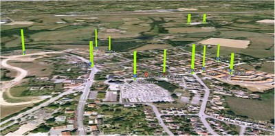
- 9:30 to 11:30. Moving in the suburbs of Limoges: Landouge. Located in the suburbs, this ancient village has been gradually absorbed by the city of Limoges and is an outstanding example of urban sprawl. Different measurements of noise as well as numerous photographic plates were taken.
- 11:30 a.m. to 12:00. Measures of sounds around the waste of Landouge with Jerome Le Crom, technician of the urban city of Limoges. This association with the city of Limoges can locate records sonres in a regulatory obligation while discovering a professional equipment.
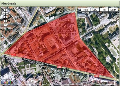
- 1:30 p.m. to 3:30 p.m.. Sound mapping of an inner-city of Limoges. The morning had helped develop survey methods along a path defined. In the afternoon, the approach was focused on autonomy with a geographical area to cover.
- 3:30 p.m. to 4:30 p.m.. Presentation by Jerome Crom about the missions of the city of Limoges in noise pollution and creation of a noise map for the city of Limoges.
2. data exploitation
- Data on sound records led to the creation of a KMZ file containing the data collected. These are represented in relief, the attitude of a meter is a decibel.
- The sound files were selected and reworked according to their possible exploitation. They went online and then integrated into the same card that records sound. The photographic plates have been the same treatment.
- Records with Kinomap were posted on their site and have been subject to special treatment..
A written summary, as a heuristic scheme, was made in Limoges and these two neighborhoods. The space was observed Landouge especially highlighted urban sprawl and the distinction between ordinary and extraordinary sounds sounds, natural sounds and mechanical sounds. These first awards have been the subject of much discussion. For example, how to classify the sounds associated with the construction of a new home in a subdivision? This is an extraordinary set of sounds to the extent that it is linked to a particular time of the sound environment, rather marked by natural sounds, but it is also a set that lasts over a year. This difficulty has emphasized the relativity of sound records, according to the scales of time and space (distance from the noise source causes deformation ...). In the case of the downtown district, it was found a predominance of noise associated with road improvements, but the moment is discharged this type of noise, there are natural sounds, without significant intervention of the rights. This second report highlights the dominance of road transport infrastructure and the notion of urban decay, urban spaces not marked by human activities.
Role of the second class in high school: Work on noise mapping in Nantes and Paris
The other class in high school has done additional work. Least half of the analyzed noise mapping of Nantes, one of central Paris. This is a work of synthesis, since the maps available for these two cities of different sizes are in PDF format with very specific elements.
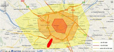
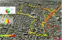
Cartographie de Nantes (réalisée avec Scribble Maps)
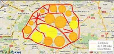
Cartographie du bruit routier à Paris (réalisée avec Scribble Maps)
This work allowed a comparison with the findings established for the exit around Limoges. An initial analysis also show differences in scales used.
Creating a simple typology of sound
In parallel with this work on mapping records sound, a typology of sounds was proposed. Many types of sounds and sound effects have been published, offering a panorama rich but complex. Because of the quality of recordings and objectives in the study, a simple typology, based on its morphology, was established.
Two main distinctions were made:
- Ordinary sounds and extraordinary sounds
- Natural sounds and mechanical sounds
These simple types have shown the prevalence of mechanical sounds ordinary, especially related to road traffic.
Excluding the sounds of road traffic, we discover, including downtown, a predominance of natural sounds, substantially altering the perception of sound. This is a finding consistent with studies on the sound, like that developed by Catherine Semidor
about sundays without cars in Bordeaux.
Comparison and synthesis of noise mapping
Comparison of the three towns cards offer some elements of analysis for two classes of second:
- Inner cities of Limoges and Paris, off road show similarities in terms of noise: the Parisian districts are little more than noisy neighborhoods of Limoges (even if it is above all the road noise in Paris).
- Transport infrastructure play a decisive role, it is the heart of management arrangements to more sustainable cities (even more visible in Paris, since this is the road noise).
- Urban sprawl is another important element of the evolution of cities. More space sold as "quiet", they are always broken sounds and loud noises, related to the construction of pavilions and other amenities.
- Urban sprawl is a problem: if the goal is to reduce or to find solutions to problems of road infrastructure in particular, it is necessary to contain sprawl by proposing a reappropriation of city centers as spaces of everyday life. Excluding noise-related communication channels, the various districts of the metropolis, whatever the scale, can accommodate this urban population in terms of noise pollution.
Conclusions and developments
This approach by the noise mapping and noise environments has allowed for a case study in geography of urban spaces in developed countries based on the problems of urban sprawl, instead of road infrastructure and sustainable development of the city.
This question also other areas:
- The preeminence of the visual over the auditory: since the Renaissance, the visual has always taken precedence over sound. This would also make students aware of listening spaces and noise environments as a priority, before reintroducing the display to show the cultural impact of this rule.
- The use of mobile devices in education: the use of mobile phones has changed the approach that could have students. However the wide range of mobile phones of students, the limited presence of smartphones have shown limitations: it very difficult to find software and common applications, without going into a catalog impossible to use: Mobile phones were used primarily Recorder digital sounds, images and videos. While these traditional uses have been provided in an educational setting again, few students were able to exploit the proposed applications.
- Digital mapping approach as a link between "scientific" noise (the sound level readings) and a more sound sensitive environments (sound recordings, definition of a typology). The use of digital mapping has provided an opportunity to mingle on the same image noise levels and sound recordings. Often there are questions of noise mapping related to the concept of noise pollution, putting aside the restitution increasingly rich sonic environments. But here, the digital mapping allows you to meet these two approaches, across a case study of high school.
Finally, this case study, although centered around three cities of different scale can be adapted to any urban space. The third class of ICT has played a special role because of its status. The teacher can also define the applications to use. Using maps of Nantes and Paris has partly overcome the lack of noise mapping in Limoges. It is also possible to work during a field trip levels and sound environments, and then compare the results with sound cards and disseminated by the corresponding urban community.
Many activities can be offered around the study of sound environments using digital mapping.
This project received the Award for Creativity from innovative teachers during the 4th Innovative Teachers Forum and Innovation educational link 2. The project has also resulted in an author interview in the Café teaching. All the achievements is available on this site devoted to the project.
Jérôme Staub, webmaster of the Geomatics day (IFE-ENS Lyon) with the participation of Vincent Marsick, professor of music education in the city school John the Baptist Darnet in St. Yrieix The Perch (87) and Jerome Le Crom, senior technician at Management Environment-Health of the city of Limoges.