Actions sur le document
Virtual approach and fieldwork: looking for a "third space"
Overview of the experiment
This experiment is an extension of one proposed last year around the noise mapping and noise environments. It
comes complete by proposing to explore new areas of the city of
Limoges, offering a synthesis of noise mapping of major French cities. The
focus is, specifically, this year on the links between virtual
representations a priori students and uses tools to track and field
location (maps, GPS, Smartphone ...). It relies on two specific scientific readings. The
first is the thesis of Jeremiah Valentine "Uses geographical
cyberspace: new appropriation of space and the rise of a" néogéographie
"" where, he experimented with the report of an adult sample locations
and tools digital location in the cemetery of Pere Lachaise by offering several instruments including the map. The second is the theory of the three spaces developed by the geographer (but not only) American Edward Soja. It
defines the third space in the introduction to his book "Thirdspace,
Journeys to Los Angeles and Other Real-and-imagined places": "Thirdspace
too Can Be Described as a creative recombination and extension, One
That builds That perspective was Firstspace is
Focused on the "real" material worls and has perspective Secondspace
That Interprets reality throught this "imagined" representations of
spatiality. " If
one proposes an educational approach of this tripartite conception of
space, it is possible to imagine that the "first" space is that students
learn through the geographical and historical texts, the organizational
patterns, images and videos that Richard called Bustin 'Firstplace: build the physical environment "(the physical environment built?). The
"second" space belongs to the world of representations "common", "the
representational space" (Bustin) that students can learn in the most
immersive exploration of virtual globes (Google Earth in particular) and
additional immersive: relief or 3D representation, the implementation of panoramic photographs and how to do "travel". The
third area seeks to link the two in a previous approach of "lived
space" of the first mixing experiences and expectations of the second
("Thirdspace: The" Lived Space "- the experience in Firstspace
mediated-through Secondspace expectations" Bustin ).
This work shows the various issues addressed in the work environments of sound and noise mapping but with different approaches. If both classes have collaborated second, third class could not play its role of experts. In
fact, these are the elements of the previous experiment that served as
the basis for the preparation thereof, in an effort to extend and engage
alumni. The
overall approach remains the same: "This experiment is part of the new
geography curriculum of the class II (Theme 3:" Develop the city,
"chapter" Cities and Sustainable Development "). According to the
official instructions, this topic
is addressed "from two case studies put into perspective, the one
chosen in developed countries, the other in emerging or developing." It
is organized around three main issues: that of the growth
and urban sprawl, that of transportation and mobility, and finally that
of city planning "sustainable". It is based on a field trip to a nearby
urban area (ie Limoges), which can be
adapted to other cities. For the first case study, the choice fell on a
set of French cities at different scales: Paris, Lyon and Limoges.
Entering this case study is done by the study
of noise mapping and noise urban environments, pollution vectors and
facilities in cities characterized by urban sprawl and the issue of
communications lines. "
Duration:
Like the previous work, the mobilization of this work lasted a few weeks to propose a feasible set within established programs. On the scale of several school years, the goal is to offer this type of activity with different inputs in order to supplement and update the sound mapping of Limoges.
Objectives:
The objectives of this experiment are plural:
- Propose a collaboration between several classes.
- Refine work on mobile tools in addition to smartphones, digital tablets and is refining the selection of applications.
- Highlight the three types of spaces presented above, especially by working out before and during the release of tools and location scouting.
- Propose a different approach to the analysis of urban space through the sounds, building on existing work.
- The concept of course work in the city thanks to GPS.
Setting up:
Overall plan
This experiment is based on different types of documents:
- A noise mapping available for Paris and Lyon, conducted by professionals across a large metropolis and a city..
- A fieldwork to meet noise and sound levels with mobile devices (tablets, smartphones) to construct a sensitive mapping of the city center of Limoges.
This study points to common ideas but also to identify significant differences, depending on the importance of the metropolis.
Progress
This activity involves two classes and the same level:
- The first (second 5) is the output of Limoges, collecting data, interpreting them through a mapping.
- The second (3 seconds) and working noise mapping analysis of Paris and Lyon.
The work of both classes is pooled with a summary and for the two classes of second. This summary is also based on work previously conducted by students of the previous year.
Work on the second 5: discovery spaces to explore, make f ieldworkand creating cartographic collection.
1. Preliminary work: discovery of space to cover the main sights and sounds possible with Google Earth and StreetView
This first step is to familiarize students with the space they have to cover the day of release. He set to highlight the spatial representations and sound students. These are used to compare the results a priori and a posteriori.
Fieldwork map
View Larger Map
Some examples:
These are the three areas defined in StreetView that were previously chosen by most students. The spreadsheet corresponds to the percentages of different types of sounds selected from the files of students (here are the different types of sounds represented: road traffic, no pedestrians, work, wind, dialogues between people, birds, transport, noise from shops, car horns, truck unloading, church bells, market, animals). The final link is the soundscape really collected the day of release.
Place de la Motte
Lire l'ambiance sonore captée.
Avenue Jean Jaurès
Lire l'ambiance sonore captée.
Place Denis Dussoubs
Lire l'ambiance sonore captée.
Une synthèse des résultats sur ces trois espaces:
A first synthesis
The selection of students focused mostly on places downtown, the communications hub within the city, the strong symbolic spaces (like the town hall), main streets known. The sounds reflect the visual elements present in panoramic photographs, especially the sounds of traffic and pedestrians. If the second observation is correct, this is not the case for the first.
2. The fieldwork: discovery of sounds through various mobile tools
A. Equipping students
Depending on the capabilities of each, groups of students are at least equipped with an IGN map and a plan of Limoges, a GPS (or a mobile application using GPS smartphone or tablet) , a digital recorder or application of sound recording, a sound level meter or equivalent software for smartphones.
B. Course of the fieldwork (see location map above)
The first part is to present the work: about half an hour, a common path is conducted to show how the tools can work and propose a first approach to listening to the city. next time is to assign each group a sound space to capture and analyze. The afternoon allows for implementation of greater autonomy, a zone being defined for everyone, such constituencies to allocate a portion of the work involved.
This work resulted in two leu synthesis maps. The first, as a slideshow ArcGIS, you can see and analyze the course of student groups with GPS
:
View Larger Map
The second is the set of soundscapes recorded during the fieldwork
:
View Larger Map
C. Conclusion
A more sensitive on different sites and communications nodes downtown highlighting the links between overall impression, analysis, audio and visual aspects.
3. A questionnaire after the fieldwork
To assess students' feelings about the use of mobile tools and urban sounds, a questionnaire was given to students.
- Question 1: What instruments did you have available to do this job?
- Question 2: What are the instruments that you have the more you used it to find?
- Question 3: What are the instruments that you have served more to record sounds?
- Question 4: What are the instruments that you have served more to raise the noise levels?
- Question 5: In your opinion, what are the most reliable instruments to achieve this output?
- Question 6: In your opinion, what are the most practical tools to achieve this output?
Some results of this survey at the scale of a class (results summarized around the meter, the paper map, a digital recorder, smartphones and tablets).
Question 7 focused on the sounds that most students scored during the fieldwork
Work on the second 3: Paris and Lyon
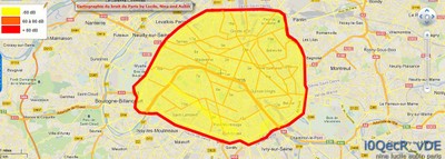
The work of the other second grade class has to implement a work in Paris and Lyon, in connection with the work previously performed last year on these types of cards. This is to emphasize the idea of a bank mapping noise levels can be used and used from one year to another.
Paris
Lyon
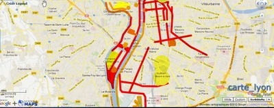
Map of Lyon is much more complex to simplify and resulted in many unsuccessful attempts, most results are partial. Indeed, the interactive site dedicated to the noise mapping provides information through a search engine, district by district. This makes the work of synthesis much less obvious ..
Synthesis
The work on the most sensitive places of Limoges are correlated with the noise levels of other cities in order to relate the quantity and quality. These elements have helped to refine and supplement the previous findings on the inner cities, in terms of noise level. By cons, last year's decision-sounds were less highlighted, which will this year offer a more sensitive approach, linked to the understanding of these strategic areas of inner cities.